Thanks for the corrections, @dennis-s, and I’ve updated the instructions to match.
I didn’t know the left trail to avoid the little loop was deprecated. I’ll check in with the Friends of Hammond Hill about that and perhaps go for the right trail.
Thanks for the corrections, @dennis-s, and I’ve updated the instructions to match.
I didn’t know the left trail to avoid the little loop was deprecated. I’ll check in with the Friends of Hammond Hill about that and perhaps go for the right trail.
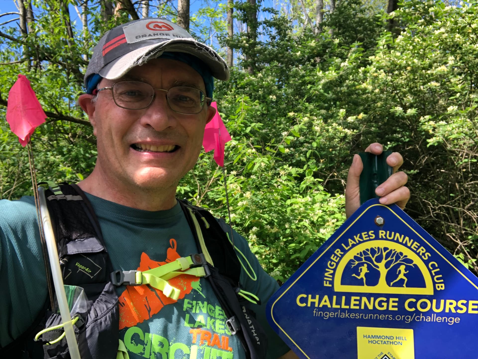
@Challengers, I confirmed what Dennis says above, and I have adjusted the RunGo directions to send you around the loop to the right at the request of the Friends of Hammond Hill trail stewards. As a bonus, the course is now just a bit longer, so you can spend more time in the lovely forest of Hammond Hill.
@Challengers Not being able to see these trails in person is killing me. Now I’ve gotten the opposite information from another member of the Friends of Hammond Hill, who says the original map was correct, and we should run on the left side of the little loop on Y8. I’ve reverted the instructions to the original and added a request to let me know if they work now. Maybe someone can post photos of that intersection.
I’ll be running out there on Saturday and if no one posts anything by then, I will be sure to get some photos. (And hopefully not get lost…)
I ran it last weekend and didn’t see the little loop on Y8 at all. I just followed what seemed like the only trail in that section. I also managed to use the wrong directions a second time.
Check out the second paragraph at this link, specifically mentioning the old ruins:
http://canaaninstitute.org/bikeskiblog/about/hammond-hill-map/
The original Hoctathon taking the slight left follows the brushed-in trail and not the blazed trail to the right. You can’t go wrong following the blazed trail. I would go by that.
Augh! ![]() I’m looking forward to Heather’s pictures.
I’m looking forward to Heather’s pictures.
Sadly I can’t make it to tomorrow’s Thom B, but at least I got my fix of Hammond DEC trails this weekend. The Hoctathon trails were somewhat sloppy, but I expect the Thom B to be mostly dry by Sunday morning. I started a double loop at 5:30 and only saw a few people out there later in the run.
The RunGo cues for the B3 loop got me thinking about the Hammond B3 organ and its use in classic rock. (Think Al Kooper’s organ sound on Dylan’s “Like a Rolling Stone”, among many other songs.) Perhaps it could be a theme for a future group run. At least it seemed like a good idea when I hadn’t much else to think about during three hours of running. Also, what’s a hoctathon, and what’s good pseudo-Greek word for double hoctathon? Dr Google, Ph.D doesn’t seem to have any idea.
I don’t see what the discrepancy is. Everyone should be following Y8 uphill — it’s clearly marked. No reason to go off the trail regardless of what RunGo says.
From the course page, where I knew this question would come up:
What’s a “hoctathon”? It’s like a marathon that’s around 8 miles long and brought to you by the letter H, for Hammond Hill!
As for a double hoctathon, since we’re all adults here, one possibility would be a seducathon. Because sedecim is Latin for sixteen and it’s oh-so-hard to resist that second loop. ![]()
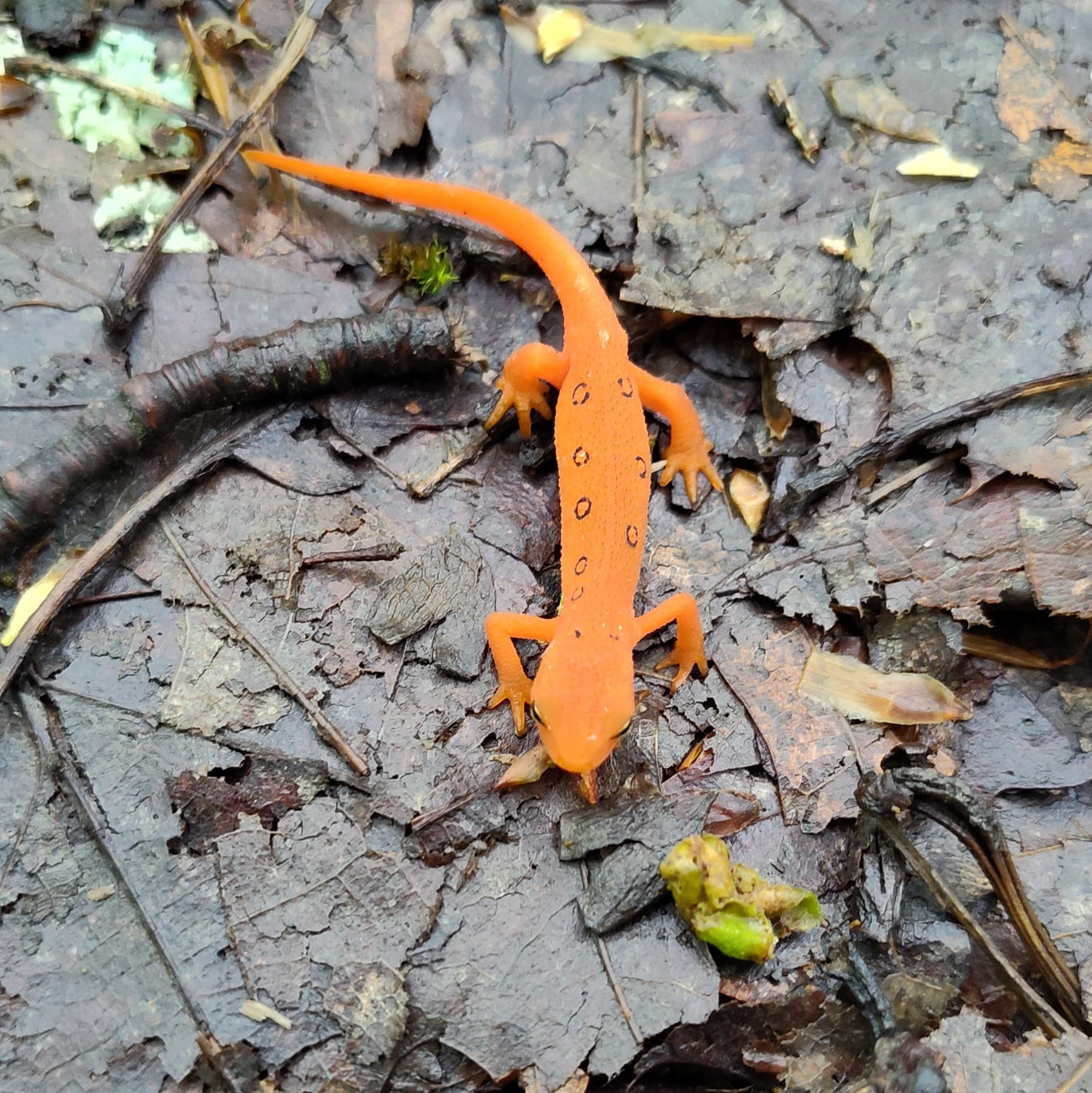
Pete was right, this was a soupy mess. I counted 38 red efts - I was hoping for 2 more to keep with the theme of the course and have a multiple of 8, but alas my eyes did not spy them. I did, however, spy a barred owl, which surprised me right as the problem directions we’ve been trying to sort out came up. What timing!
Tried to scan the QR code but none of the races were coming up. Only realized when I got home that my Webscorer was still logged in as FLRC from when I helped time the CHES 5K a few weekends ago. The run is public on my Strava.
To the Thom B runners tomorrow: may the mud be ever in your favor.
Nothing Newts-worthy to Report
After a very fun morning manning a water station at the Thom B Trail Runs, with afternoon sunshine and flowers abloom, the trail sirens were calling. I was hopeful it was still damp enough to catch site of a red newt or two, especially since @heathercobb3 found 38 the day before (my personal daily record is a mere 11 by comparison at Heiberg Forest, but that was also the same run where I saw a fisher, a large snake, and rousted a turkey from the brush that startled me just as much). Alas, I still carry an o-fer this year.
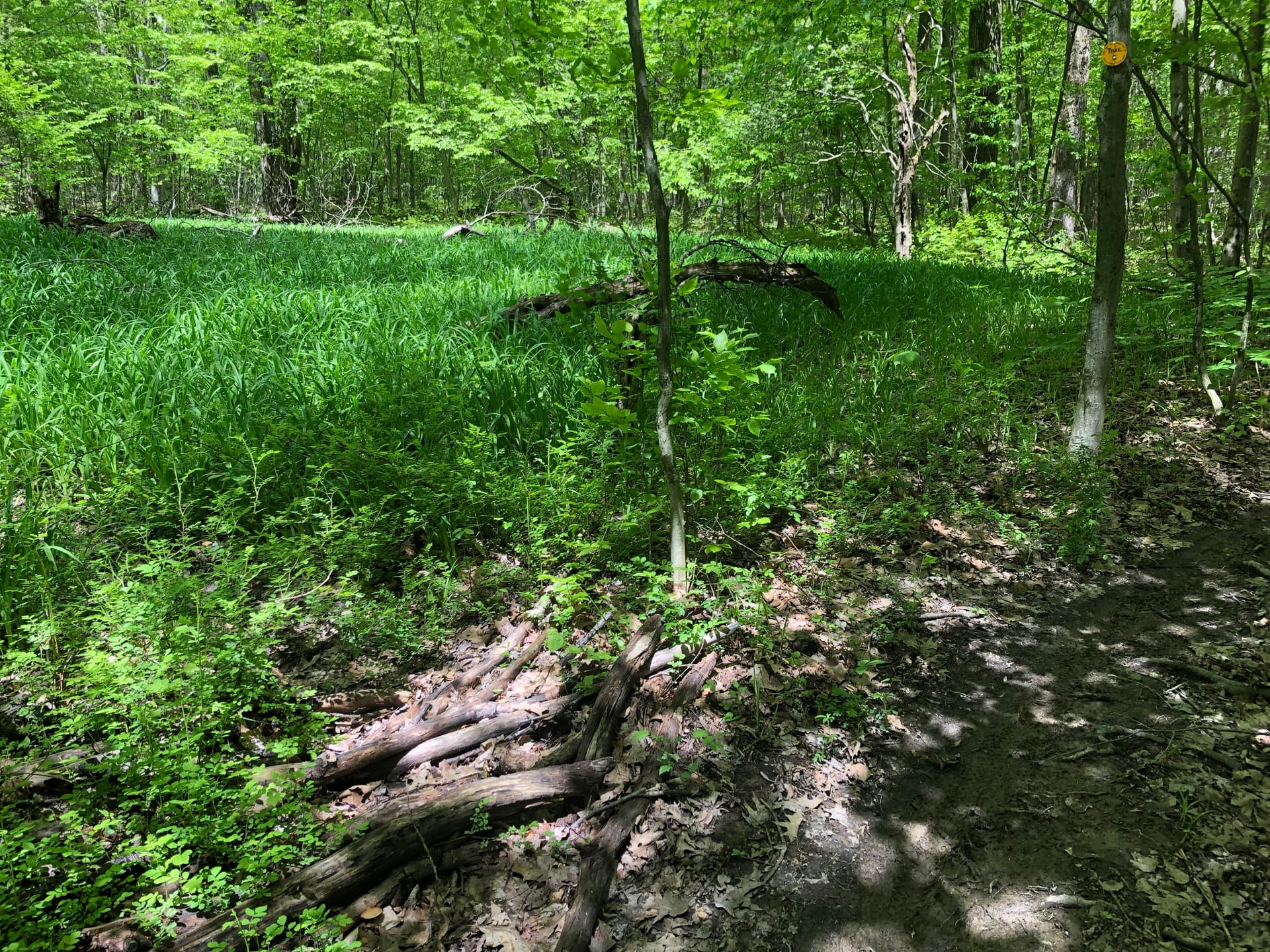
Following is a photo of the trail “junction” that has been the subject of some discussion. The yellow blaze on the tree on the right is the official sanctioned trail that does a little loop to the right around some ruins. Numerous branches have been placed to block the old trail to the left. I’m not sure what RunGo directions are currently, but original directions said to take the left, which by all indications is no longer supposed to be an option. Fortunately, it is easy to miss the banned trail to the left, especially as the grasses have grown taller.
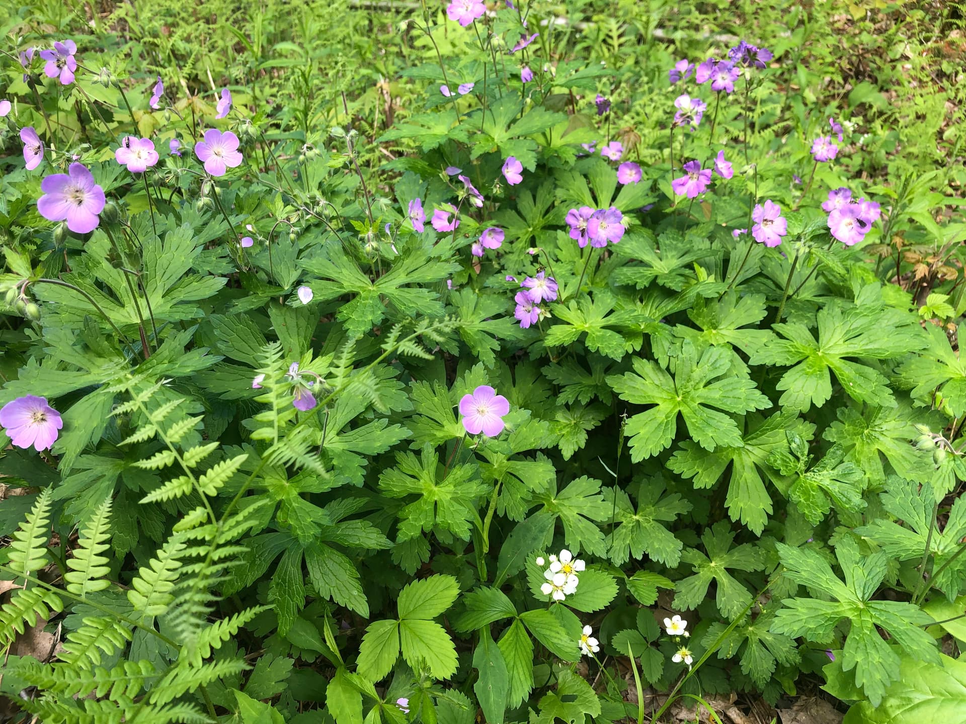
The trilliums are fading a little but still very impressive along one stretch of trail, and there are still numerous purple flowers coloring the trail.
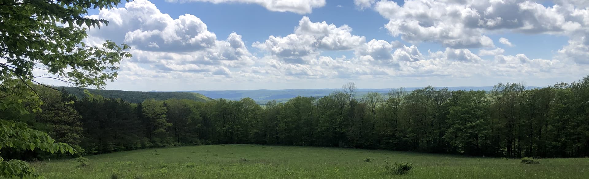
Does this view have a name?
Other than one biker, I had the woods to myself and enjoyed a small scavenger hunt on course sections that overlap the Thom B, where I found one empty GU packet and 4 course flags left behind.
For those of a certain age or certain reading persuasion, Tom Bombadil was a legendary character, eternally youthful, endlessly traipsing through his beloved woods.
For 2 hours today, I tapped into that spirit - unexpectedly, delightedly. This run was far beyond anything I had done in 6 months, yet continued the recent progression through the various Challenges (Valley View, 6.4; Treman Trailipop 7.x). But as I was out at Hammond Hill anyhow helping time the Thom B, I thought I take a chance. I created a window of opportunity between setup and timing opportunities - then lay awake most of last night worrying that I wouldn’t hit that window for one reason or another.
So, after a couple of hours of restless sleep, I roused myself and belittled my fears - was out on site ready to help at 6 am. After the marathoner start at 7 am, I slipped into my running gear and headed out. The RunGo app was still displaying the Hammond Hill Hackathon route, which I was grateful for as I had no cell coverage. I carefully started my watch as I scanned the start into the Webscorer - and headed out.
I immediately discovered I was a liar - I had told several racers picking up their bibs that there were no steep hills on the course, but I had forgotten the darn road hill, mostly because I avoid it when running there casually. So I ran up it as penance, figuring I would pay for the effort later. I was amused at the gate (finally) blocking Hammond Hill road, and easy access to B1, but it really wasn’t much of a hindrance.
Settling in onto running, I began to appreciate the beauty of the day. There was no wind, and no rain, and very few bugs - I got nabbed by a mosquito early on on my leg, and was a little concerned, but that was it. The trails themselves were relatively dry - though with the requisite amount of mud - and interesting. And the RunGo app was working well - both vocally through the Shokz bone phone and the GPS tracking on the map. I hadn’t run the snowmobile trail before, so enjoyed the gentle descent down to Canaan Rd. On prior runs, I had gone through the Canaan/Y7 juncture, so while I wished there was a Y7 marker at the entrance into the forest, I breezed in. I wish I could say the same about the Y7/Y8 juncture…for some reason, I started down Y8, but quickly realized my mistake and reversed course.
After about 30 minutes, the pre-run coffee and apple fritter (thanks, Mr Hector!) wore off, and I fell into a routine of consuming a chew every 10 minutes or so with a swig of water while just cruising along the trails. This was the part of the forest that I remember - constantly rolling, but no steep ups or downs. Made the turn onto Y5, and then onto R4, grateful that none of the Thom B runners were nearby, as I wasn’t running their course. The RunGo app kept me company and on course as I turned onto Y4 and passed the halfway point, always waiting for this bubble to burst, but enjoying the ride while it didn’t.
As I approached the Star Stanton juncture, I was greeted by @Ian and @dennis-s who were manning the Aid Station for Thom B. Their cheering momentarily disoriented me, but Dennis got me going in the right direction towards Y2 - and onto familiar turf. The Y1/Y2 loops are a favorite afternoon dog walk so I entertained myself ticking off landmarks - the turn here, the shortcut to Y1 there, etc. Turning on to Y1, I was very aware that I was back on the Thom B race course, potentially ahead of faster runners. Sure enough, I heard voices behind me, gaining quickly, as I descended down Y1 toward Star Stanton. As the voices drew closer, I wondered how hard they were working, as at least one was breathing heavily. The mystery was soon solved - a yellow Lab came bounding by, ahead of a pair of mountain bikes and another Lab. There was a respectful, uneventful pass - I marveled at how close the trailing dog was to the bikes.
By now, I was through 7 miles, and could begin to feel the effort - and the finish. I had discovered the B3 loop, so was familiar with the Y1->Y3->B3 transition, as well as the B3 loop itself - a little gem in the middle of the forest. The exit onto Y8, and then the subsequent turn onto Y6, was just the usual route I take in reverse, so I focused on my form, as I didn’t want to fall now. I kept waiting for the magic to end, but was beginning to believe that I could make it. And I began to see others - the Wilderness Rescue staff, Jamie Love taking pictures, and marathoners on their 2nd loop going the other way.
I wasn’t out of the woods yet, though, physically or metaphorically. As I approached Y6/B1 intersection, I kept one of the marathoners on course - but then inexplicably turned up B1, right into the fastest one-loopers. Fortunately, RunGo piped up and warned me that I was off-course…but then, when I reversed course, thought I was just starting rather than finishing! At this point, though, I could finish in my sleep, and just about did. Amazingly, the detour didn’t sap my spirit, but rather reinforced my desire to run to the finish - and I did! I knew there would be a number of Thom B volunteers at the end of the run - so I gave them a rousing chorus of “He’ll Be Coming Round the Mountain” as I passed on my way to the Challenge sign, gratefully clocking out. I was amazed to see I was several minutes under 2 hours - even with the missteps. Never imagined that would be the case - and as such, was early for my 9:30 am Thom B volunteering assignment on the timing team.
It was only MUCH later, when I was home and showered, that I discovered that my watch had not acquired a GPS signal. So I had to resort to the RunGo data for my posting:
And, for the record, my Goldberry was happy to see me ![]()
Thanks! @heathercobb3 also provided some photos and since the grass has grown, it’s easy to say “stay straight on Y8” now.
I was in my happy place for the first several miles (both figuratively and literally, Hammond Hill is one of my favorite places to hike/run) with the sun filtering through the canopy, but as the temperature increased, the struggles started around mile 5 – I saw a red tailed hawk take off from the forest floor with a squirrel in its talons, and I couldn’t decide in that moment which one I would rather be ![]() .
.
Luckily, with 1 mile to go, Gaia offered a reprieve when the clouds opened up. Maybe this day wouldn’t be a hot slog after all?
Part 1 - Duck Trails
2 - Hammond Hill.gpx (198.0 KB)
Part 3 - FH Fox
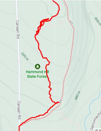
Bill, I think RunGo is correct at that intersection. The left on Y8 is a pretty hard left. Y7 veers left after you go straight through that 4-way intersection and eventually intersects the Hoctathon course again. I made that mistake when I ran the course before the Challenge officially kicked off because I initially didn’t see the left on Y8. It took a few hundred feet before I realized I was off course on the map.
Hammond Hill Decathon?
Even with RunGo directions, I managed to make a few wrong turns. I ended up going just shy of 10 miles in 2:03.23, so not terrible. And I still had a blast. Now that I know the trail, I’ll have to go back out and get a better time.
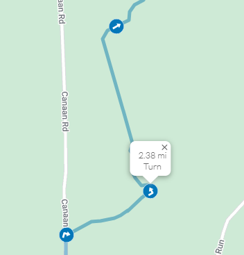
Heads up, there is a goof with RunGo. At mile 2.3 the directions say to go “left on Y8,” but Y7 goes left, Y8 goes right. I decided to follow the trail number instead of taking the left. The directions should be “go left on Y7”
Maybe the trail markings are off, someone who is running through there next should check. But on a map, Y7 definitely goes straight, and Y8 (which is not marked on Strava’s map) goes left. I compared your Strava to mine (below) and RunGo (below), and your map bows out to the right when it should have bowed out to the left.
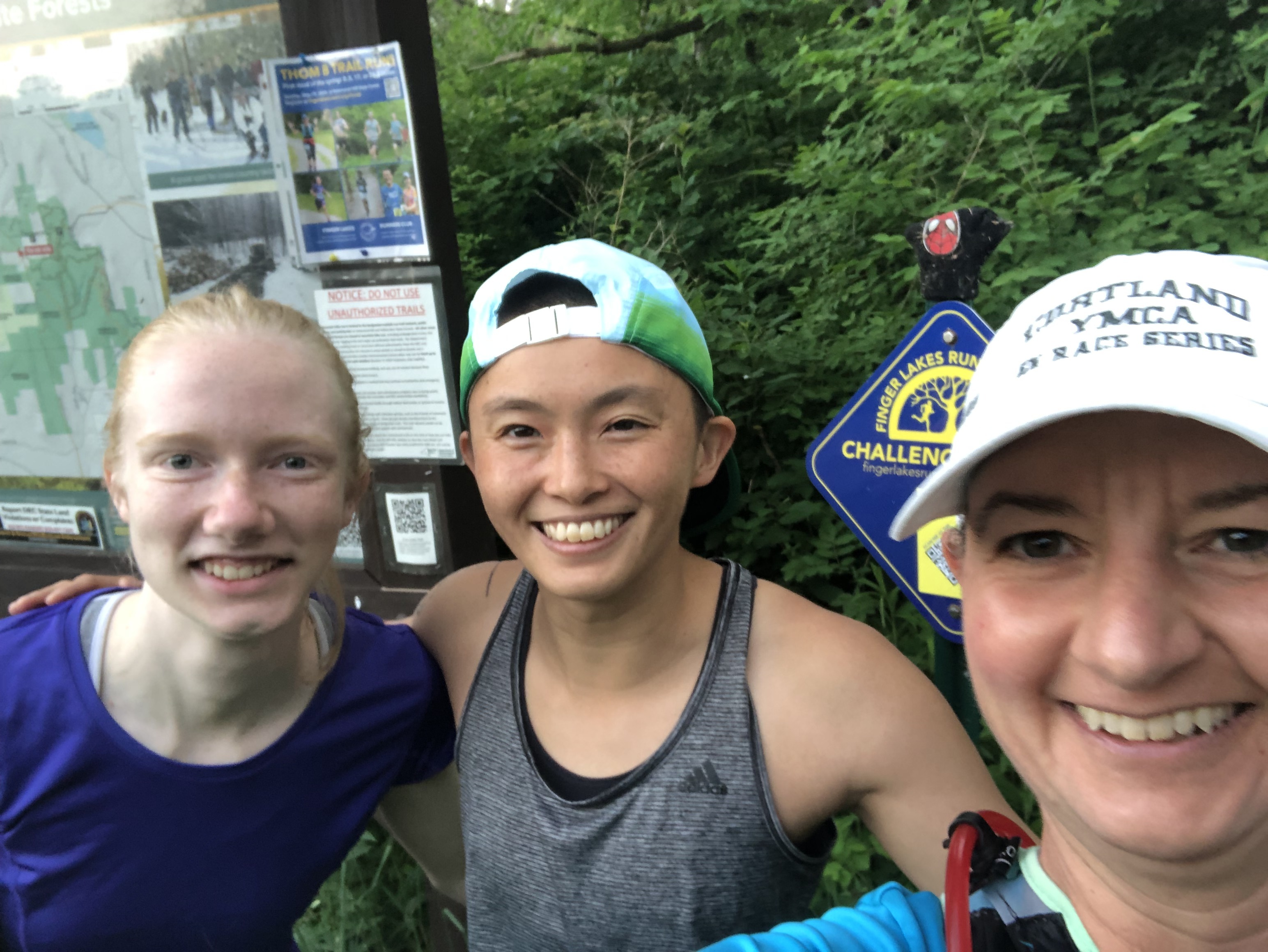
This was the first course on my Tough Trail Challenge. @gplwoo committed to joining me on my adventure even after running the 50k at Cayuga Trails this weekend! Happy to have a crazy and committed friend. We were also joined by one of other running friends Emily.
Enjoyed the course and ran some trails I’ve never been in before.
My friend and I are planning to run this course on Thursday 6/13 in the evening. We are hoping to get done in around 2 hours. We would love to have company to run with if anyone is interested. We would especially love it if someone who is familiar with the course joined us so I don’t give us any bonus miles like I did last time I ran this course.