Sure, let me look into it. It would give me an excuse to pay for RunGo for the club, which feels like a fair trade given how useful it is to us.
2 Likes
I ran Duck Trails this morning and all the cues were great except the first right - “Turn right 0.12 mi”.
This came too late and had me turning at the second right, at the pond. On RunGo it looks like the turning point is in the middle of the two possible right turns. Other than that I had no issues.
1 Like
I ran Valley Views this morning - and said “Hi” to the horses, as suggested. ![]() There are two directions on the course that could be better:
There are two directions on the course that could be better:
- When you’re on Perkins Rd. close to the Gravel Pit headquarters, it tells you to “continue straight and enjoy the big machinery and the gravel pit”. I recommend it tell runners to “turn right on Valley Rd. and enjoy the big machinery…” At that point, if runners continue straight, they will run to a private driveway. The road curves to the right and becomes Valley Rd.
- When runners are near the end, Brookton’s Market is in sight!, and they are running to the intersection of Valley Rd. and Brooktondale Rd., the directions tell us to turn left on to Brooktondale Rd. ??? However, the way runners are oriented at this intersection, Brookton’s Market is directly across the road. The instructions then tell us to turn right to go to Brookton’s Market. I recommend that at the intersection, the instructions should tell us to just cross the road (being careful to look for traffic) and finish the run at Brookton’s Market. I forgot to take pictures. I can get out there again later today, if that would be helpful. All in all, this is a very enjoyable run with lots of nice views.
Good suggestion, Gretchen, thanks! They were super easy to make and I’ve done that now.
1 Like
I’ve moved that turn right at 0.12 miles back a little and added that you should run further from the pond, so we’ll see if it works better next time.
Here are the suggestions Diana and I thought of for Treman Trailpop:
Right away, specify going right at the Y. I had this issue the first time I ran the half marathon in 2022, and went to the left down to the water because I knew I had to cross the water.
1.92 miles: the trail looks like it splits. Specify going left onto the field
2.06 miles: specify going right, back into the woods.
2.25 miles: no voice directions to turn left onto the highline pole path.
3.58 miles: specify turning left up the stairs.
3.94 miles: specify turning left at the sign.
5.51 miles: specify turning right into the woods off of the highline pole path.
5.7 miles: specify turning left into the field
5.82 miles: specify turning left, back into the woods.
Fun fact: there are over 300 stairs on the Lake Treman loop.
2 Likes
I forgot to note that Run Go showed there was 730 feet of elevation gain on this course. ![]()
That’s weird. I’m using the iOS version and assumed something that simple would be the same on Android.
@adamengst Looks like you or someone else already fixed some of the HHH cues. I cleaned it up a little to make the audio cues more clear and concise. I tried to this the same day I ran it but it kept losing data every time I added or moved a point, which never happened to me before. Seems to be working okay now.
@melissawallace Thanks for the suggestions on the course directions. I took notes and had all the same suggestions as you. It should be good to go now.
1 Like
I ran FH Fox this morning and it was mostly fine except the below areas, which Rebecca mentioned, too.
-
1.64 miles - “Turn left - back on to the trail”. It might be better to say “Go straight on the grass and turn left - back on to the trail.” At this spot you’re on the dirt road which goes right and it’s very natural to want to go right instead. The grass trail before the left was not very apparent.
-
3.01 miles - “Turn slight right - to stay on the Cayuga Trail through the Cornell Botanic Gardens fields” - this took me way off course (see RunGo track). After backtracking I saw that should have just gone straight and up the stairs, not towards the fields on the right before the stairs. It might be better to say “Go straight and up the stairs.”
I had to use my phone to make sure I was on track for the next section until the Weeping Willow cue. Might be worth saying something like “follow the trail with the ridgeline to your right,” which I think was generally what I did. FWIW, this area wasn’t really a “field” to me.
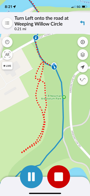
(Dotted red line shows where I went slight right into what looked like fields; no mention of stairs in the cues, which would have kept me on the blue line.)
The Freeville Fly-In RunGo directions look great! The only thing is I was short on time and had to turn around 0.5 miles before the course turns around at Warren Road. The 12 miles I ran were spot on.
1 Like
Here are some preliminary edits for Run Rabbit Run. I’m going to run this course over the weekend instead of tonight, but I was reviewing the directions beforehand.
4.79 mi “Head straight onto Agard Road”
This should read “Head straight - across Agard Road” or “Head straight onto Jacksonville Road”
10.99mi “Turn slight right onto Taughannock Park Road”
This is potentially a duplicate direction as it is listed twice at this distance.
I’ll add more edits to this, once I complete the course.
GPX files are now available for download on all the course pages. I’ve also embedded the RunGo map on each one rather than messing with a static screenshot. The RunGo maps are interactive and provide a list of turns as well.
1 Like
These were kind of tough to put in, since I’m not sure your distances matched up with what I could see exactly. The ones I’ve added that I’m uncertain about now say “Check this instruction,” so the next time someone runs this, please record how accurate all the “Check this instruction” steps are.
Great suggestions, Rebecca, and these are all in. I think I got all of them cleanly, but worth testing again soon.
I think I’ve fixed this. The problem is that the trail doesn’t go through the fields at the bottom, which is the High Noon canonical route. Instead, it goes up the stairs as you both found. I think it’s easier to follow the trail on the map rather than free-forming it in the fields below. But we’ll see.
Good stuff, Patrick, thanks! I nudged the ones you said were late back a bit and fixed up the rest. Ready for another try!
These fixes and some more from @amalia are now in. Thanks!
I think I’m caught up on the playtesting now, but it’s easy to keep tweaking these as we go.
Just a note for the playtesting @challengers — all the signs are installed except for Duck Trails, which I’m meeting with the Lab of O about on Tuesday.
I have to adjust the Lindsay-Parsons start/finish slightly in RunGo to match the actual sign location.
Adam, this is a reminder to adjust Duck Trails to mention how the first two right turns are on the bark chip trail.
Already done. ![]()