This is pretty obvious, and many of us know (some of) this area from the Thom B race, skiing, or the activities of Mike Ludgate’s “Canaan Institute” bike and runs. But for those of you who don’t know, there is a well-marked trail system (small DEC coloured disks), a variety of terrain, the Finger Lakes Trail crossing along the NE edge of the area. Maps and information at http://www.dec.ny.gov/lands/8204.html. Easiest access is the parking area near Ann & Charlie Leonard’s farm near the N end of Hammond Hill Road. Do not try to drive Hammond Hill Road from the south!!
From this parking area a fairly easy run begins across the road at the information kiosk, follows trail Y1 gradually uphill to the Tob de Boer memorial bench with a nice overlook to the west. Another parking area is at the end of Red Man Run, off Canaan Road. We pass this on the Thom B run. This gives easy access to the FLT in both directions. This saddle is pretty muddy in season.
Lots of people who run in Ithaca have never made it out to Hammond Hill, which is a darn shame, since the trails are great. That said, I’d generally recommend running with a friend who knows the trails the first time or two since it’s pretty easy to get turned around. In an ideal world, we’d be having group run-throughs of the Thom B. course in April and May.
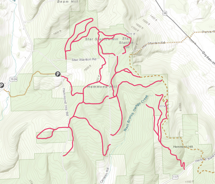
If you do want to head out there on your own, the Ithaca Trails site has excellent maps, but it can still be tough to follow them on the ground. Bring a phone if you’re running by yourself, but beware that cell service is spotty. Here’s the map for Hammond Hill.
Good points Adam, indeed not everyone has a good sense of direction/the sun is not always shining. My experience with t-mobile is … forget it! A compass will help orient you. And if totally lost, just head downhill and sooner or later you will come out at a house or road. Maybe after quite a bit of bushwacking or stream wading… so yes, best to go out with an experienced runner. Also, if you get injured up there it’s a long walk back to help.
Get lost going downhill on the right road, and you could end up at High Noon President for Life John Saylor’s house.
I’ve never tried using the iPhone’s built-in compass app while running, but the one time I tried orienteering (out at Lime Hollow, years ago), I was seriously humbled at how tricky it was to navigate by map and compass alone. I figured that my running conditioning might make up for my lack of navigational skills, but no. I got my head handed to me in the race, and found out later that I had run about 10 miles instead of the 6 miles that people who could navigate well did.
For anyone not overly familiar with Hammond Hill and who’s interested in running the Thom B loop, I’ve created a Cal Topo map of the 8-mile route. https://caltopo.com/m/9712. There’s no cell service in most of the forest, but you can save the map and turn-by-turn directions as screenshots and go from there.
I ran the loop today and it was ice- and slush-free. Soggy in some spots, but hey, nothing’s perfect.