Good day, @Challengers! Now that things have settled down from the club’s six races in January, I can refocus my attention on the FLRC Challenge. Here are my proposed courses for 2024.
Sweet 1600 (1.0): Any track, anywhere, although there’s a possibility we’ll have another carefully measured course on a local farm.
Duck Trails (2.7): This is a short trail course on the Lab of Ornithology trails near the airport. They’re soft and pretty and a gentle introduction to trail running.
Lakefront Loops 5K (3.1): As like last year, you’ll also be able to submit any 5K race time for this road course, but this year you need to post about the race too.
FH Fox (5.0): For those at Cornell and on East Hill, this mixed trail and road course uses the familiar Dryden Rail Trail and makes a new connection across the famous FH Fox bridge over 366 and returns on the Freese trails.
Valley Views (6.4): This road course brings us back to Brooktondale and uses a lot of Valley Road. You’ll understand the name once you run on Burns Road.
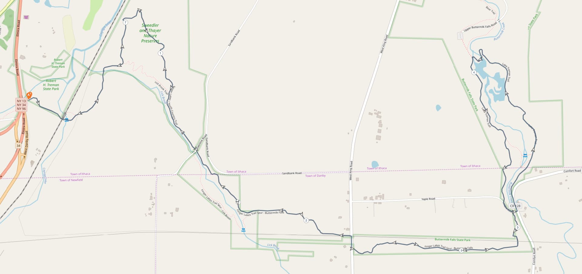
Treman Trailipop (7.7): This trail course starts at the Lick Brook parking area, as we did two years ago, but goes up only the Lick Brook side, continuing out to do a lollipop around Lake Treman at Upper Buttermilk.
Hammond Hill Hoctathon (8.6): We run at Hammond Hill a lot, but this new course uses a bunch of new and previously unused trails.
Run Rabbit Run (11.1): Our Trumansburg area course is a Figure 8 that uses the Black Diamond Trail and provides starting points at Kraft Road (where we may have a porta-potty again in 2024), the upper parking area of Taughannock State Park, and the village of Trumansburg (handy for post-run socializing).
Freeville Fly-In (13.1): Starting and ending at Campbell Meadows (which has its own lovely but very short trails), this long road course takes you on a tour through rural Freeville, by the Cornell Experimental Ponds, and near the airport.
So the question for you is if there’s any special knowledge you have about any of these courses that would require rerouting or replacement. (And if you have any clever name suggestions that are better than what I have here, I’ll consider them.)
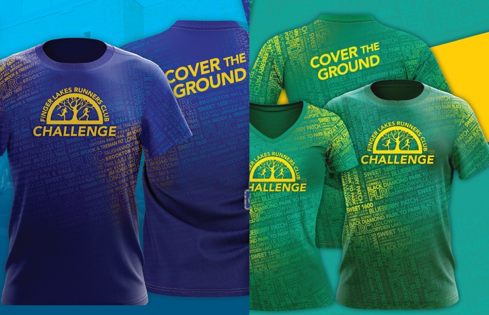
The course names are important in part because they’re the background for the shirt. I’m planning on sticking with the same basic design this year but with new colors. It has been great to see people rocking the yellow-on-blue shirts from two years ago and the yellow-on-green shirts from last year. Here are a few combinations I’m considering—vote for your favorite. No promises, but I’ll see what works as we get into design.
I’ve had birders get annoyed by my quicker fartlek pace (and I by their 3 person wide obliviousness) when I’ve been at the Lab of O. They have a new 1.5 miles of more XC style trails (like Lansing Center) that might be better than the mulchy stuff.
I’ve specifically gotten permission for us to use the Lab of O trails from the facilities people there, so they’re aware that we’ll be there. There’s nothing we can do about other trail users other than try to be polite, but at least the people in charge are cool with what we’re doing. It has also been suggested that serious birders don’t really care much about what’s around the Lab of O—it’s a nice walk, but there aren’t particularly interesting birds. I’m sure the airport doesn’t help.
The new trails are scheduled for drainage work this summer so they won’t be available this year and I was asked to avoid them explicitly.
Hi Adam,
This is such a spectacular event and I know that a lot goes into it! I tried to view the Freeville course but it was blocked. This is an area I’m familiar with and have some thoughts depending on the course. If it will spend time on Etna Rd. I will say that the shoulder is limited and cars tend to go fast. I have ideas for how to avoid it if needed.
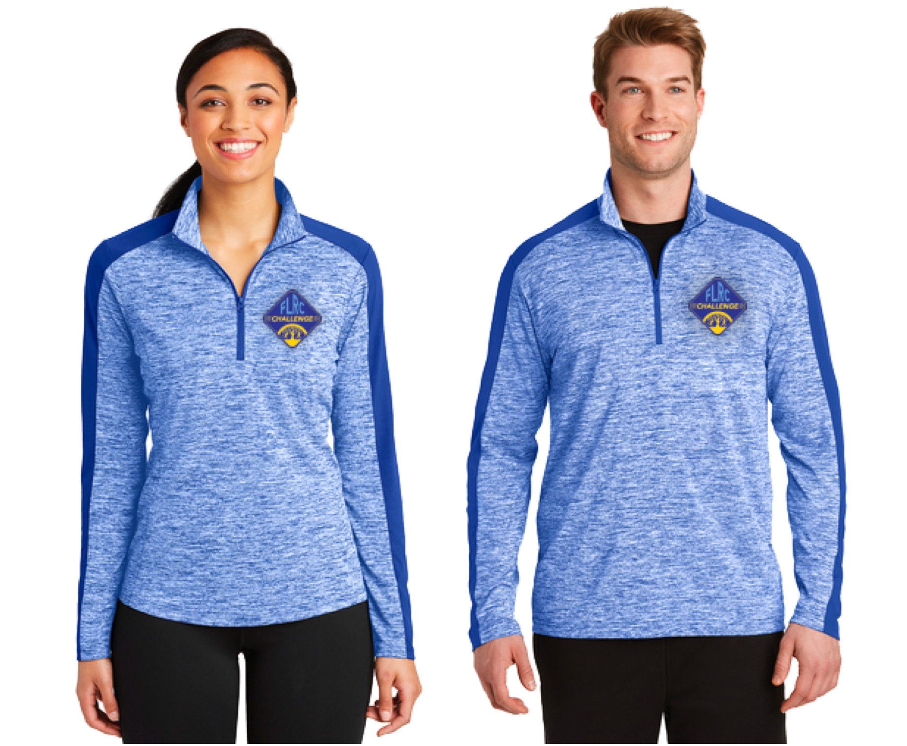
Also, is there any possibility of offering a 3/4 zip top in addition to the tshirts? I’m a tshirt hater so would love a different option if possible.
Oops! @Stephanie_Mulinos, try that Freeville Fling link again—I failed to make it public so it was only working for me. (The mapping service I most like, On The Go Map, can’t do satellite imagery anymore, so I can’t use it for trails well, so I’m trying others. I don’t like MapMyRun much, which is what I tried for this course, and Plotaroute is full-featured but very hard to use.)
The course has to use some of the faster West Dryden and Etna Roads, but spends much of its time on the smaller roads in the area. And of course, a lot of runs don’t take place during the commute hours, when all those roads are quieter. I spent many days biking those roads this summer and fall since it was all I could do, so I’m really familiar with them as well. If I wasn’t trying to keep the distance to 13.1 miles, I could avoid the big roads more.
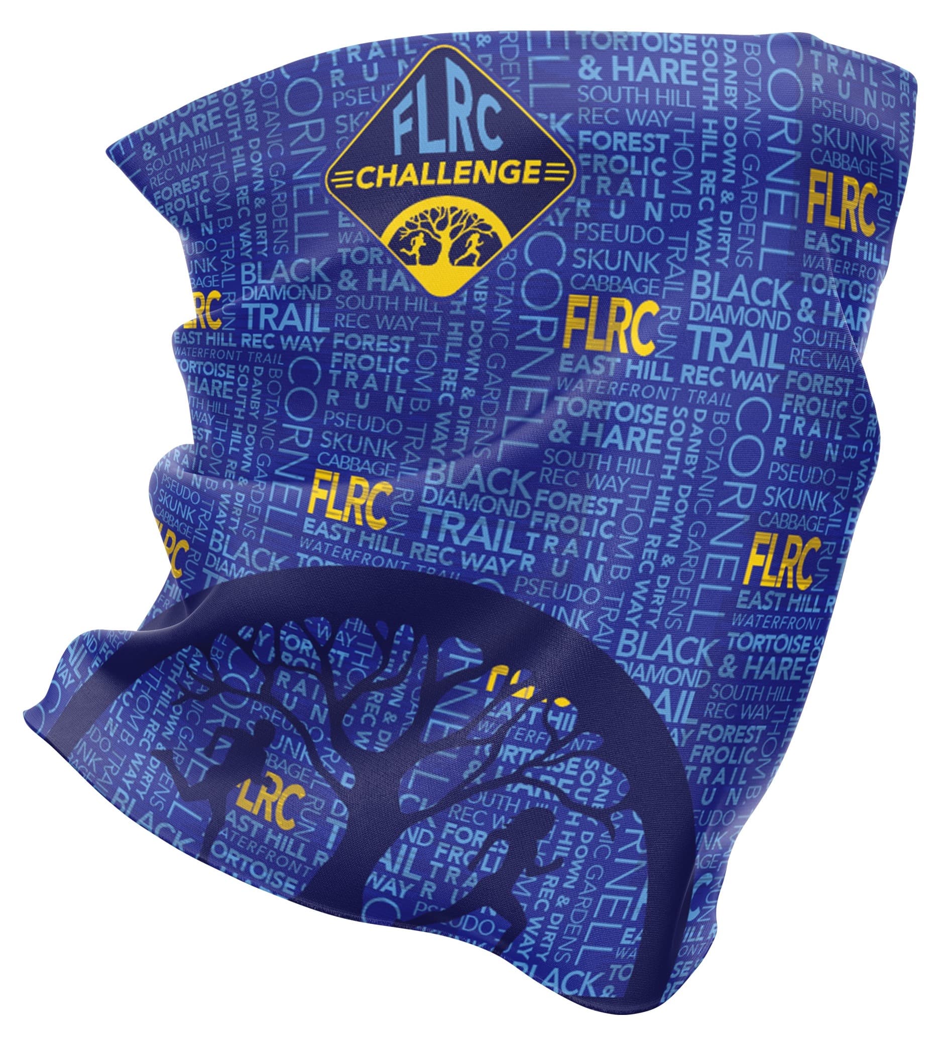
We did a 3/4 zip the first year (and a buff), and while I like it fine (it has a patch for the logo), I’m much happier with the fully sublimated designs possible on T-shirts. The other issue is that I want people to be able to wear the swag during the Challenge itself, so I’m aiming for summer wear, rather than long sleeves. The first year of the Challenge went from February to the end of the year, so a long-sleeved 3/4 zip made more sense.
@mplank People seem to have rather divergent opinions about buffs; some love them; others never wear them at all. I opted for one the first year because we were just coming out of the pandemic and people were still wearing them partly in place of masks outside. I only started to wear mine this fall as a head covering that fits under my helmet when biking in temperatures under 45. There are probably some people who have a buff from the first year who would be happy to move it on to a good home.
Now, it’s not unthinkable that we could do a separate 3/4 zip that’s designed as an outer layer, though it would be fairly expensive given the relatively small volume we’re doing for the Challenge. Of course, if we’re getting into custom club swag, all sorts of things are possible (we had some requests for a club sweatshirt today too), but I’d need help. Distribution in particular is an effort because there isn’t a single race date where most people show up to get their swag.
I am very happy with the trail choices. Some old familiar runs (Lab of O) and some new areas where I have never been (Lindsay Parsons). Thanks for doing all this work Adam!
Jamie
Name-wise, the eastern side of the Lab of O course kinda looks like a duck’s head and the potential name “Duck Trails” occurred to me as a still bird-themed possibility, so throwing that name out there. Bonus, you can sing it to the tune of the show “Duck Tales.”
Another maybe more straightforward potential option, ‘Sapsucker Sprint’ or something similar.
I’m so looking forward to the Challenge again this year! Thank you thank you for all the thought & work that goes into it!!
I did a singlet for Trackapalooza, and I’m still gauging how popular that style is, particularly with those who race infrequently or not at all. We couldn’t sell them as part of registration on MileSplit for Trackapalooza last year, so they didn’t sell all that well then. At the last track meet, however, they sold pretty well in person, which suggests that at least track athletes like the style.
Oh, oh, that’s good. I’ll give that some serious consideration—the appeal of the “Lab of O” name is just that it’s highly locationally descriptive, but “Duck Trails” works really well based on the birds that live on the ponds you run by and the general ornithological connection. And while I’m too old to have ever watched “Duck Tales” (I was in college when it premiered), I certainly read the comics its characters came from as a kid.
Yes! This was my favorite show as a child in the early 90s. I recently tried to get my kids interested in because they already know the characters but they weren’t too into it. With the tie-in to the Challenge on a course I can walk with them, they’ll hopefully reconsider.
I’m looking at an April 20 start date (a week later than last year due to Skunk being later—I need the time after Skunk to put up signs) and a Sep 1 end date (two weeks later than last year since the Annual Picnic will be September 19 instead of in late August).
BTW, the reason they did not approve a Challenge Course on the Monkey Run trails is because they were concerned that those trails are already overused.
Oh yeah, forgot to respond to that. Tonya’s right—the Monkey Run trails are fairly heavily used for the condition they’re in already, and the Cornell Botanic Gardens Director of Natural Areas felt that encouraging more foot traffic would cause even more problematic erosion.
Cornell land is managed by many different departments, so the Duck Trails course at the Lab of Ornithology was approved by Lab staff, not Cornell Botanic Gardens. It’s often unclear who is in charge of what, but I can usually find out with a few emails.
This all looks great! My only concern is with the Treman Trailipop. Conditions are likely to be pretty gnarly (deep mud) from what I’ve heard for much of the season depending on how much rain we have. @gvanloon, what do you think of the course?
Good question. @Petorius, @Ian, any thoughts here? I know the Lick Brook trail we ran two years ago to King Road and that was basically fine, and the park trails around Lake Treman won’t be muddy.
But I don’t know about the trail section between King Road and Comfort Road that basically parallels Yaple Road. Is that likely to be a problem? If it’s really nasty, we could allow Yaple Road as an alternative—it looks like it’s about the same distance.