@adamengst this isn’t directly about the courses but it is about the Challenge. My dad is 84 and he can’t run anymore (due to Guillain-Barré Syndrome years ago) but he still likes to walk and always sets personal goals for himself. Scott and I shared about how the young kids can set personal challenges for themselves for a number of courses to hit, and how the focus is to cover the ground vs requirement of running). He is interested in signing up and setting a personal challenge if we are open to extending him that opportunity. What do you think about this?
That’s totally in the spirit of the Personal Challenge, and please do encourage him to sign up and contact me to talk about what he wants to set for his Personal Challenge. It’s not in any way limited to kids.
Looks like we can do tank tops in both normal and racerback style in the same design. Without as much material on the shoulder and back, it may not have the same impact, but I’ll see what we can do.
Just a note that the Fall Creek Trails course had to change a bit after consultation with my contact at the Cornell Botanic Gardens. They have some trails that are more fragile than others and some that we think of as standard aren’t actually official. Here’s the new map, and it’s now 5.4 miles, so it fits in a little better anyway.
Looks like the darker red and yellow combination is the most popular, so I’m moving ahead with that.
Since we have to stop at Gorge Road on the BDT, I’ve renamed that course to Black Diamond Cass to Gorge.
One quick request for @bobtalda or @Petorius or someone with mapping skills—could you check these distances and elevations? I don’t entirely trust some of the mapping tools I’ve been using.
| 2025 Courses | Distance | Elevation |
|---|---|---|
| Sweet 1600 | 1.0 | 0 |
| Mulholland Waterfalls | 2.7 | 506 |
| Lakefront Loops 5K | 3.1 | 34 |
| Lansing Cliffs | 4.3 | 745 |
| Fall Creek Trails | 5.4 | 490 |
| Town & Gown Up & Down | 5.9 | 596 |
| Abbott Ascent | 8.0 | 1707 |
| Black Diamond Cass to Gorge | 8.2 | 460 |
| Triple Hump | 9.2 | 1083 |
| North Country Half | 13.1 | 953 |
Adam:
Glad to check out elevations - will do Mulhulland Friday, and either Fall Creek or Town&Gown on Sunday…that is, if Pete hasn’t done them all by then ![]()
Sorry, I wasn’t clear. There’s no need to run all these courses right now (though playtesting is always welcome!) What I’m mostly interested in is a double-check on the mapping to get elevation numbers. Running a course will just put a track on a virtual map with elevation data, so it’s no different from just mapping it again or downloading a GPX from RunGo and putting it into a different system to verify the elevation data.
I’m not sure what you’re asking for if not running them. Mapping them on a map system other than RunGo?
The Abbott numbers are very close to what I’ve historically measured when running the loop.
Mostly just looking for a sanity check on those elevation numbers. I just don’t have a feel for whether the mapping apps are making stuff up, and elevation isn’t a metric that I think about much.
Adam:
Attempted to export data for Mulholland Trails from RunGo and ran into a paywall; I need a “Premium” subscription. Sigh. Anyhow, I was focused on that run because that elevation makes no sense. My partial run today - from the start to the turnaround - showed 100 ft of elevation. (And, as you know, there is very little climbing after the turnaround). And a sample run from my house
https://www.strava.com/activities/323278502
showed an elevation of 254 ft …
Anyhow, will have to up my RunGo subscription …
Bob
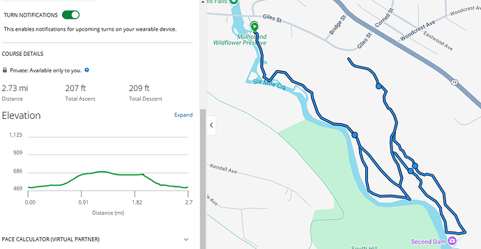
Here’s the GPX (FLRC has a premium account that I use to create all these). It claims 506 feet of elevation.
But I wonder what the definition of “elevation” is in this context. Is it how much you go up AND down, given that we’re starting and ending at the same point? Or is it only the vertical climb, such that downhills don’t factor in?
Mulholland Waterfalls.gpx (13.8 KB)
I put the .gpx into my Garmin Connect as a course and it is stating 207 for total ascent and 209 for total descent.
So what do people consider the proper definition of “elevation” then? Just ascent, or both ascent and descent? If it’s called “feet of climb,” that’s just ascent. But if it’s “elevation change,” that would imply both.
This only really matters for the number that goes on the shirt. ![]()
I consider elevation the “feet of climb” which does not include descent.
Those numbers mostly seem accurate to me based on past experience, assuming they represent elevation gain and not elevation change. I’d list the Lakefront Loop at 0 but it’s up to you. Black Diamond depends what direction you’re running, but if it’s stated as Cass to Gorge then 460 is about right.
The only one I’m not confident about is Mulholland. It looks ok for the elevation gain, but since @heathercobb3 mapped something a lot different I’m not so sure. It seems like multiple ascents from the 6MC gorge should be over 300’ of gain though.
I second Amy’s request for a tank! I find if it’s warm enough not to need long sleeves, I would prefer a tank over a T shirt. Thanks for all the thought and effort that goes into this, I look forward to the challenge every year.
Thanks. I will!
