WHAT: The FLRC trail race season is kicking off this month. As part of that the directors—Nancy Kleinrock (@nkleinrock), Steve Shaum (@SteveShaum), and Steve Vanek (@Steven_Vanek)—of the Two Hollows Monster Marathon and Half will be leading a casual group run this Saturday morning on the brand new course, covering beautiful trails you might never have run on. WHERE AND WHEN: The start will be at the corner of Adams Road and Owego Hill Road in Harford. As is usual for FLRC group runs, meet at 8:30, start running at 8:45. There will be snacks afterward. DETAILS: The HM course is 13.1 miles, with a 9.5-mile option and a 6.5-mile option for this run-through. Be prepared to carry fluids/fuel if you think you’ll need them, noting that we’ll pass by the cars (and the stuff in them) at 9.5 miles. IMPORTANT DRIVING NOTES: Do not approach via Owego Hill Road from the north, as it’s not passable. Instead, approach via Daisy Hollow Road (either from the north or south), but note that Adams Road has no road sign where it intersects with Daisy Hollow Road, so you should rely on your navigation app. At the intersection of Adams and Daisy Hollow, turn onto the paved road and go up, up, up the hill. PACE: Please vote in the poll below with your average trail-running pace so others can get a sense of who else will be running their pace. We welcome a wide range of runners.
Pace Poll
Sub-8:00-minute pace
8:00-9:00-minute pace
9:00-10:00-minute pace
10:00-11:00-minute pace
11:00-12:00-minute pace
12:00-13:00-minute pace
13:00-minute+ pace
I plan on hiking
0voters
CARPOOLING:
Let’s try to reduce the number of car trips to fight climate change. Vote if you need a ride or can give one, and post a reply with meetup ideas.
Is the course blazed/flagged for those who want to test it out solo? The FLT is blazed but most of this course is not on the FLT. Looks like an interesting course.
Go north on Owego Hill from the intersection of Owego Hill and Adams taking the Spanish Loop (orange blazes), turning into the woods 0.2 miles from the start
Follow orange 1.4 mi to its end at the intersection of the Spanish and Finger Lakes Trail (white blazes), turning right onto the FLT
At the road crossing (Hilsinger Road), turn left on the Swedish Loop (blue blazes)
Stay on the road for 0.5 mi, turning into the woods to stay on the blue blazes; during the race, there will be an aid station here
Stay on blue 0.9 mi until it intersects with the FLT (be sure to keep an eye on the blazes to stay on trail; it’s a bit tricky)
Turn left on the FLT (white blazes) and stay on it as you cross the creek, turn left, go along the stream bank and go up, up, up, cross Owego Hill Rd, up some more, finally flattening out and descending, where you’ll once again reach the intersection with Spanish Loop
TURN AROUND and follow your way back on the white, blue (including the 0.5 mile on the road), and right into the woods on the FLT back to the intersection with the Spanish Loop.
Turn left onto orange until you get back to the cars. You’ll be at ~9.5 miles; if you chose not to do the “turn around” section, above, you’d be at ~6.5 miles now
To continue for the HM distance, continue on the Spanish Loop (orange) as it turns right on Adams road, passes one house, then quickly turns right onto a brief cleared pipeline section and then heads into the woods—stay on the orange blazes and stay off any road you might come near
Cross a powerline and a very minor creek after which you need to be careful to stay on orange. Keep staying on orange, even when it takes a hard left turn (going straight would put you on the English Loop (red blazes; you don’t want this)
Remain on orange until you see the opportunity for a blue-blazed trail (Irvin Trail)
Take blue until you cross the next powerline (notice the chairs and mailbox and take in the big view)
Turn right onto the Spanish Loop (orange) again immediately after reentering the woods and go down, down, down through some switchbacks
Just as the trail looks like it will start flattening out, go straight onto the Polito Path (red blazes) for 0.1 mi
Turn left on Erics Path (yellow blazes) for 0.15 mi
Turn right on the Irvin Trail (blue blazes) until it Ts at the English Loop (red blazes); turn right
Take red for 0.1 mi to Five Point Junction
Turn left on the Spanish Loop (orange) at Five Point Junction and take that down to the turnaround at the lower intersection of the Spanish and English Loops; you’ll be just above Daisy Hollow Road at this point.
TURN AROUND AND retrace your steps to the cars.
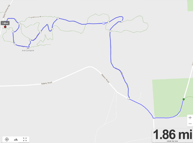
Here’s a map of the western section of the course:
In the app on your phone, if you tap the compass/bullseye icon, it will show your position on the map in real time, which can be helpful when navigating such a network of trails.
The blazing out there is excellent, thanks to trail maintainer extraordinaire Alex Gonzalez.
Thanks. I knew about Alex’s trails lower down but didn’t realize he had worked on trails so far away from Daisy Hollow. I’ll check out the phone. I never get phone service in the country (T-Mobile grrrr…) but if the trail is downloaded I guess it can be followed. I am good at finding things in the woods, even with the printed map I think I’d do OK. Will report back. Maybe can make it on Sunday but I am probably slower than everyone, age 74 and mostly run/walk combination. Last time I came to a group run they all took off and left me behind (Hammond Hill a year or so ago) so that turns me off to the group runs.
To clarify, this run is on Saturday; there’s also group run at Hammond Hill on Sunday (I’ll be helping at that one, too).
With a limited number of group leaders, a wide range of paces, and a complicated trail network, it’s useful if folks have a copy of the map, whether physical or digital.