Possible courses for 2023 FLRC Challenge

@Challengers, it’s time to start finalizing the course list for next year because it takes some time to get permissions and make RunGo directions and the like. Here’s what I’m thinking currently. And read everything, since I need your help to come up with some additional trail courses.

  1. Sweet 1600: Although this “course” is the least interesting locally, it makes for the best postings and pictures when people are traveling, and quite a few people said they really enjoyed the encouragement to find tracks to run on while on vacation.

  2. Ellis Hollow Nature Preserve: This is a slightly more than 2-mile trail course just off Ellis Hollow Creek Road, just past Genung Road if you’re driving east out of Ithaca. (The link goes to the very first RunGo directions I ever did and isn’t quite what we’ll do, but it’s the best map I have right now.) It may be short, but it’s a great little trail course, with singletrack trails through scenic woods with challenging hills, multiple stream crossings, and highly variable surface. It’s an excellent starter course for those getting into trail running, and experienced trail runners can log multiple efforts without getting bored.

  3. Cass Park 5K: I haven’t quite figured out the best 5K course here, since the Twilight course is a little too complicated without course marshalls and the Winter Chill course doesn’t include the Treman Marina trails that are so nice. But it’s doable. The twist with this course is that it’s a fast, flat paved 5K, and you’ll be able to submit any accurate 5K race or parkrun anywhere in the world as well. The goal here is to let people race 5Ks elsewhere and include them in the Challenge, much like the Sweet 1600. But it’s a lot harder to find a 5K than an open track, which is why I’m including both.

  4. Trail Course TBD Something in the 4-5-mile range. See below for ideas.

  5. Trail Course TBD: Something in the 5-6-mile range. See below for ideas.

  6. FH Fox Freese Trail: For our Cornell area course, I’m looking at bringing in the East Hill Rec Way and the start of the Dryden Rail Trail, and then using the Cornell Botanic Gardens trails on the other side of Flat Rock. It’s a 6-mile course that’s extremely pretty. The only potential catch is that it requires going over the Freese Road bridge, which is open to pedestrians but not cars right now. If the Town of Dryden is planning to work on that bridge and eliminate pedestrian access during construction, it could be a problem.

  7. Trail Course TBD: Something in the 7-9-mile range, but not too technical. See below for ideas.

  8. Full Black Diamond: We’ll be returning to the Black Diamond trail again this year, but using the entire 8.5-mile length. The twist is that you can run the entire thing starting from either Cass Park or Taughannock State Park to increase the geographic diversity. Thus, you have four choices: the entire thing in either direction, or halfway and turnaround starting from either end. Yes, the fastest times will likely be set starting in Taughannock and running all the way down to Cass Park, but that’s going to require fussy ride logistics, so I expect most people to do that only a couple of times. Except Pete, who will just run back and forth a few times.

  9. Salmon Creek: Our long road course is moving out to Lansing this year, starting and finishing at Ludlowville Park, which has parking and a lovely little waterfall. It’s 11 miles of low-traffic country roads and combines both scenic creek access and long ridge views across the lake. Yes, there will always be one hard hill on this route, whichever direction you run it, but the scenery is worth it, and there’s always a matching downhill. It even goes by the Lansing track if you want to pause and pick up a Sweet 1600 too.

  10. Dryden Lake Lollipop: After complaints about how Lick Brook & Treman FLT was too hard for the longest run, I’ve brought our longest effort down to something that will be long but not technical. We’ll return to the Dryden Rail Trail, but start in Freeville (near Toads for post-run ice cream), run the rail trail into and through Dryden (more ice cream), and out and around Dryden Lake before returning.

Trail Course Ideas

Here’s where I need your help. Since I’m not healthy enough to go run everything that I’d like to try out, I need some feet on the ground. A bunch of people have suggested ideas, and I’m curious to see specific proposals. Before I get into the possibilities, here’s what I look for in a Challenge trail course:

  • Reasonable parking. It doesn’t have to have a full parking lot, but people shouldn’t feel that they’re leaving their car in a problematic space.

  • Reasonably easy to follow, with RunGo directions. Loops are generally preferable, but out-and-backs are OK. We can’t mark a course like in a race, so it has to be pretty obvious how to stay on course without getting sucked onto interconnecting trails.

  • Scenic trail that’s not too technical. Any reasonably fit adult should be capable of at least hiking the course. Nothing should be harder than FLRC trail races.

  • Provides geographic diversity and introduces people to trails they may not be familiar with. I don’t want to repeat exact courses from previous years yet.

All that said, here are some of the main ideas I’ve gotten from folks:

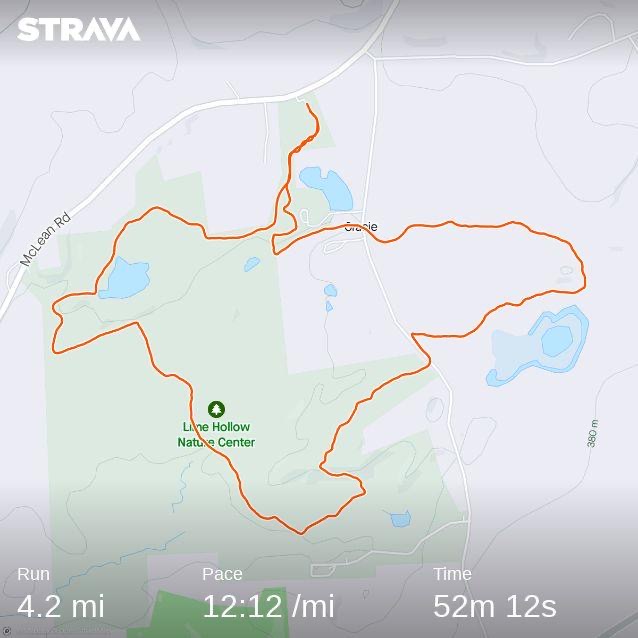
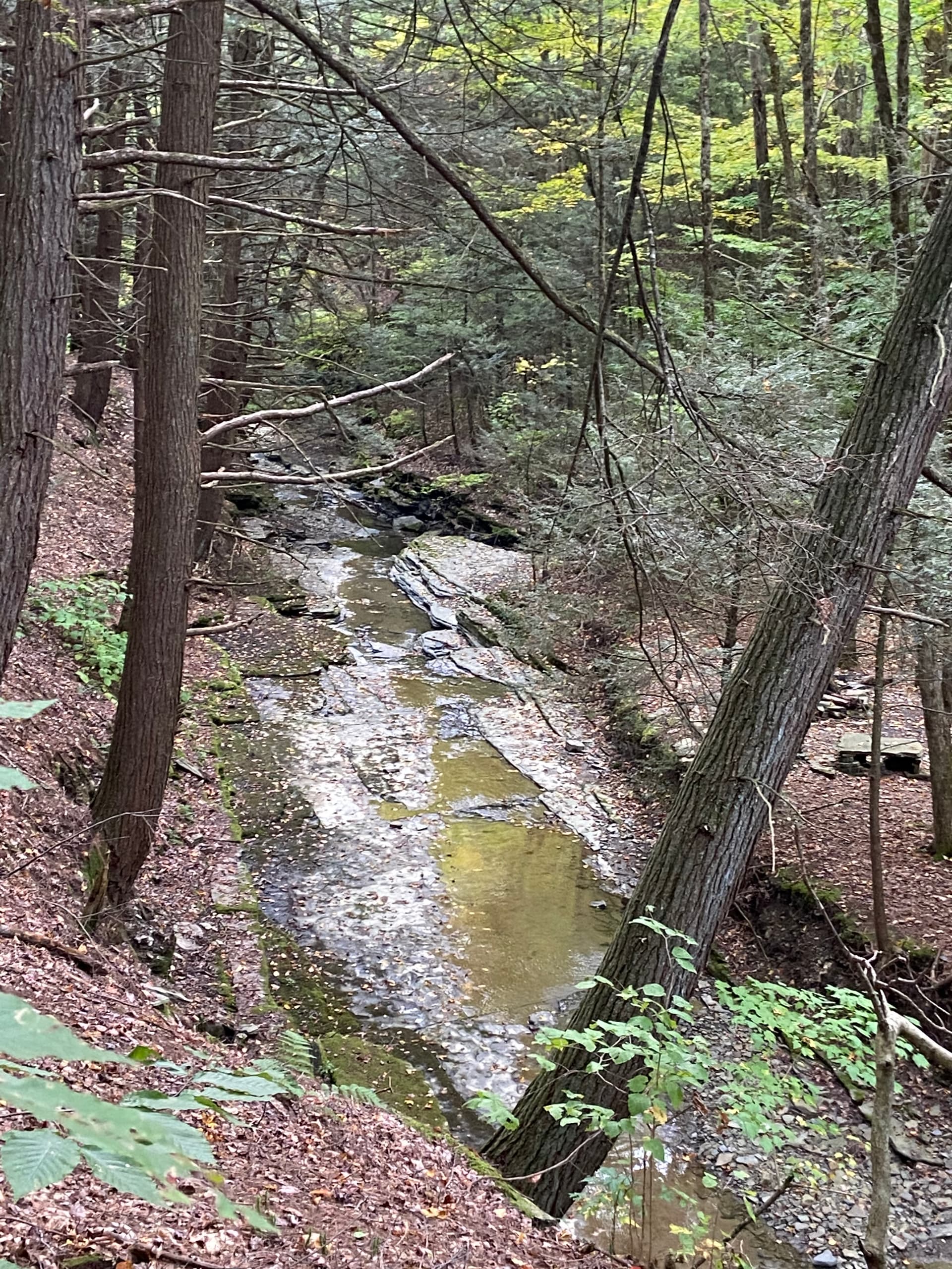
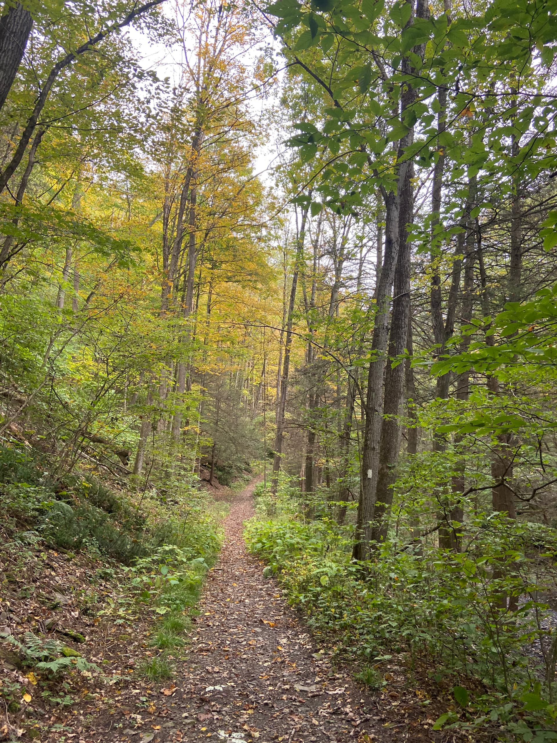
  • Lime Hollow?: Julie Barclay has been agitating for a course on the Lime Hollow Nature Center trails and has volunteered to see if she can map out something. The Lime Hollow Nature Center is in McLean, and increases our geographical diversity for the folks in the Freeville/Groton/Cortland area. The trick here will be figuring out a course that can be followed easily enough, since there are a ton of trails here. Julie, can you share some possibilities in the 4-5 mile range?

  • Abbott Loop?: Kristina Harrison suggested that we could return to the Danby Down & Dirty trails, perhaps extending to the Abbott Loop (which is about 8 miles?) or using some other trails in that area for a different distance. Some of the trails in this area may not be official, so we’d have to be sensitive about that and stick to the official ones. What would you suggest specifically, Kristina?

  • Robinson Hollow? Crosby Woods suggested some out-and-back courses in the Robinson Hollow State Forest off Rt 79 across the Tioga County line. These would be pretty hilly and technical, but are scenic. Crosby, can you share what you’re thinking here?

  • Shindagin? Several people have suggested Shindagin trails south of Brookdtondale, and Tonya and Heather did an exploratory hike out there a while ago. The issue here is finding a coherent trail that’s not too confusing, since there are a lot of interconnecting trails. Also, it’s mostly a mountain biking trail area, so we’d want to be sensitive to interactions with bikers, who can move pretty quickly. The FLT hits here too, but would likely need to be an out-and-back. Any specific thoughts here?

  • Connecticut Hill? Banyan Love and Crosby Woods have both suggested some courses out here, perhaps an out-and-back on the FLT. But another possibility would be to use some dirt roads for chunks of the course—they’re nice running surfaces too. If people out in the Newfield/Enfield area can propose some specific options, we can discuss.

  • Hammond Hill? I’m torn here—I love Hammond Hill and the trails are wonderful, but we have done two years in a row. I could come up with a 5-mile course pretty easily (the split between the Short Loomis and the Long Loomis) that would be new, but not all that new. Holding this in reserve if we can’t come up with something newer.

So please, reply to this topic with Strava tracks or OnTheGoMap maps so we can see what the possibilities are and discuss.

Thanks!

Dear Adam,

Another vote here for Connecticut Hill! I’d be happy to go and try out any routes for you when I’m back in town (away in Indiana until Friday).

Any chance of a 5-6 mile course in Treman? The FLT + Rim Trail loop would make a nice, challenging mid-length trail run without asking too much of people.

Another nice short option is Bock-Harvey Forest Preserve (possibly plus FLT by Treman Center). Then people can park close to Stone Bend Farm and go for pizza afterwards…

Best wishes,

Verity

@adamengst I second that FLT/Rim Trail loop at Treman. The Rim is much easier than the FLT comprising the Treman Lick Brook course and you can easily do a 6-ish mile loop. The Rim Trail is one of my favorite local trails to run when I’m going west to east (downhill).

A possible start/finish spot is Dennis’ Ice Cream Stand on Rt-13. There’s a short spur trail from the stand to the FLT, marked with disks on trees that have pictures of ice cream cones on them. However I don’t know how much parking Dennis’s has or what dates they’re open seasonally.

1 Like

Lime Hollow - this is a fun spot to run but only if you know your way around. There’s tons of short trails, and the longer ones are loaded with twists and turns. Trying to navigate a 4-5 mile loop could be tricky, even with RunGo. It’s a 30-minute drive from downtown Ithaca.

If we use this, another possible starting spot is Lamont Circle Park. (It doesn’t show on a map, but trust me, it’s there and has ample parking.) Start and finish at the park and run the Lehigh Valley Rail Trail 1.5-ish miles west straight into Lime Hollow Nature Preserve. Run a singletrack loop around the preserve, and run the rail trail back to the park for a lollipop course. Or start at the Lime Hollow parking area where there’s bathrooms and do a shorter route without the rail trail.

Abbott Loop - 8 miles is a good distance but I think this is the toughest 8 miles anywhere in Tompkins County. It’s a good previews for the Down & Dirty but a lot of people will struggle with it if they aren’t used to running trails. Per mile it’s tougher than the Lick Brook Treman course, and it’s more remote. as much I’d like to see it included, my opinion is it’s not a good fit for the Challenge.

We could make other loops in Danby State Forest using the pink-blazed Dove Spur Trail (pending a DEC permit). Apparently this trail was created a few years ago and then abandoned and no longer an official state forest trail. It’s marked well, but no one is maintaining it now. FLRC could consider adopting it and commiting to its maintenance, but that’s a separate discussion.

Robinson Hollow - The FLT here is pretty technical, especially as it goes uphill and north into Hammond Hill from Hartford Slaterville Road. It’s also not very well marked in some spots. I don’t think it would be a fan favorite if used for the Challenge.

Shindagin - The FLT doesn’t allow bikes here, but all of the DEC trails do. We could possibly do a loop using the FLT and dirt roads, split about 50/50 between singletrack and forest road, but that could be a turnoff for trail runners (It would be for me, anyway.) Either way, we’d have to be mindful of mountain bikers — the FLT crosses the DEC trails as several points.

Connecticut Hill - These trails are fun, but the FLT here is only marginally easier than the Lick Brook Treman FLT and it’s another one that’s about 30 minutes from downtown Ithaca. One possibility is the 6-mile Van Loon Loop, with parking on Gulf Road. The loop is about 1.5 miles of dirt road and 4.5 singletrack, with a beautiful flat section alongside Cayuga Creek and a gut busting climb out of the ravine. (Update: I think this loop depends on a washed-out footbridge being repaired.)

Other Conn Hill routes could be an out-and-back FLT as already mentioned, something involving the 2.4-mile Bob Cameron Loop on the forest’s north end, or even a route comprising nothing but a hilly forest road loop, which I think would be pretty cool.

Hammond Hill - This is such a popular, fun, and accessible spot that we should consider using it again. Bring the Thom B Loop back into the Challenge or a 100% forest road loop.

Other possible courses: Ithaca College Natural Lands (2-5 miles); the blue-blazed singletrack in the six Mile Creek gorge on the south (Rec Way’s) side; an out-and-back on the new rail trail at lower Buttermilk using the recently opened “bridge to nowhere” (possible spot for a flat 5k, instead of Cass); a trail course using some of Nancy’s “International Loop” on the west side of Kennedy State Forest, which also would serve as a preview to her revised Monster course.

1 Like

I Like some of Pete’s suggestions here and replace one of these with the Ellis Hollow Nature Preserve. The EH Nature Preserve is pretty small area with possible confusing intersections along with bringing much traffic to a pretty small, protected Land Trust property.

Lots of great ideas folks, and remember, I’m going to need specific proposals, since I just can’t get around any of these myself right now.

Treman Rim: Two votes for the FLT/Treman Rim trail sounds good. My questions there surround parking (I don’t want to make people pay for parking for each run), if the trail has a lot of stairs, and how trafficked it is with hikers during the summer. If someone could share a specific course, that would help, since I don’t know that area.

IC Natural Lands: Several people have mentioned the Ithaca College Natural Lands and the trails behind Hospicare. My main hesitation there is getting permission since Ithaca College hasn’t been particularly welcoming in the past. Parking would also be an issue—IC tickets heavily—and the trails can be hard to navigate (I’ve run them in XC races). But if there’s a good course proposal, I can try to find the right person to ask.

6 Mile Creek: The trails below the South Hill Rec Way are an interesting possibility. I know them pretty well for navigation while running, but don’t have a sense of how easy they’d be for someone else to follow with RunGo. We could easily include portions of the South Hill Rec Way in such a loop—that’s a nice area too.

Connecticut Hill sounds like it has a lot of dirt road with some trail possibilities if people want to make some suggestions.

Hammond Hill is always great and a fine fallback if we need one more course.

I have absolutely no sense of the new “bridge to nowhere” trail by Home Depot/Lower Buttermilk or the Kennedy State Forest trails.

We’d see what the Land Trust people said about the Ellis Hollow Nature Preserve, but the amount of traffic would likely average out to about 2-3 people per day, which isn’t exactly a stampede.

In regards to Hammond Hill, there is the 1.25ish mile red-disced trail to the Roy H. Park Preserve that could be added on from the HH parking lot as something different. Unfortunately right now there are a number of blow downs, and the marking is a bit sporadic.

Strava: Strava Walk Activity

There are plenty of other variations-on-the-theme at Hammond Hill: The Blue-1 lollipop at the top of Hammond Hill Road, the snowmobile trail (that someone almost-invariably takes during Thom B that goes down (down, down) to the intersection of Canaan Rd and Ganowtachgerage Rd, Yellow 7, and the other spur of Yellow-2 (just off of Star Stanton Road at the top of the hill). All of these are well maintained by the “Friends.” The greatest thing about the one-and-done Hammond Hill Relay was learning so many trails that I hadn’t otherwise explored—thanks Alex and John!

Hey Adam! This was my first attempt at a Lime Hollow loop. It ended up being shorter than I wanted. I am going to map out a few other options as well.
I would recommend starting at the Visitor’s Center (rather than the suggested citizens park) as there are bathrooms there. Also, just an FYI, you would need permission from the City of Cortlandville to put up a sign at the park, not Lime Hollow. Lime Hollow stewards the Leigh Valley trail but doesn’t own it.

I’m enjoying this discussion from the southwest mountains of Albuquerque! I’d like to suggest a Connecticut Hill route that is roughly half trail and half dirt/gravel road. You can start with either portion of the loop: Google Map Pedometer / GMaps Pedometer for Running, Walking, Cycling, and Hiking

It is inevitably a gradual downhill as you move southwest away from Ithaca, but you can decide whether to brave the trail downhill and climb up on road or vice versa. I’ve run some version of this loop a few times in the snow (@julie19 came at least once when it was cold and icy!) as well as during a torrential rainstorm with @gvanloon. The route is easier than the Lick Brook/Treman 13 mile route from this past year, and provides some dirt road relief from navigating single track while still being hilly enough for a challenge. The FLT is well marked and easy to navigate in my opinion, and while the dirt roads lack signs, I think RunGo instructions would make the route obvious since there aren’t tons of roads to get mixed up with. There are a few ski trails that intersect with the FLT but they aren’t marked with any blazes.

1 Like

Thanks, Julie! 4-5 miles isn’t terrible—we do need something on the shorter side to maintain the progression. From what people have said, the main question with Lime Hollow is how easy the trail will be to follow, given how many intersecting trails there are. So if it’s a choice between longer and easier (like all left turns, or something like that), definitely err on the easier side.

Hey, Gabby! Nice to have a suggestion from afar! This looks like a solid contender. A few quick questions. Is there decent parking at the start at Boylan Road? At least a few spots or a sign or something? And is there a reason at just before 2 miles, you pop off the FLT and over to Connecticut Hill Road instead of staying on the FLT and crossing the road a few hundred meters further on? Not a big deal either way, obviously, just curious.

I’ve run that section of trail several times and always found that spot confusing. I can’t remember if it’s a reroute or just poorly marked, but I’ve gone off the FLT almost every time without realizing it until later.

The former railroad bed is freshley groomed with crushed gravel from Elmira Road / Rt 13 northeast to Stone Quarry Road. The bridge is open to allow bikes and pedestrians to cross Rt 13. Now I’ve measured it, this trail section is only about 1.3 miles one way.

1 Like

Hey Adam! When mapping the route I think Mappedometer actually chose the fastest way from point A to point B when I was clicking through, so skipping that part of the FLT just before mile 2 was an accident :stuck_out_tongue: but I agree with @Petorius, it can be a little confusing to navigate - honestly the difference in distance is negligible, it’s just a little more single track to slow you down if someone was to run this fast.

Boylan Rd: there is no formal parking lot there, but a gravel pull-off on each side with room for about 2-3 cars, and I think a little fence/gate on the north side that is fairly obvious when there isn’t too much overgrowth. Someone who has been there more recently might be able to confirm if this is accurate. There are signs for FLT single track entrances on both the north and south sides of the road, but sometimes those can be difficult to spot in the middle of summer with lots of green. One easy landmark is a small bridge that the road crosses, and pond on the north side of Boylan that is just west of the pull-off - if you hit the bridge, you’ve gone too far.

1 Like

Another thought regarding parking - an alternative option is to start at Connecticut Hill Road where the FLT crosses it (on my current route, this would be about mile 7.5). It would involve driving up a long gravel hill, but would put you close to the 3-way Connecticut Hill Rd intersection if a larger group was trying to run this route together and needed more parking space (as on Boylan, there is just a pull-off and no lot, but all those nearby dirt roads are fair game for parking as long as another car can get past). If you run the loop clockwise, this option also lets you get a big single track hill on the FLT out of the way before you get too tired!

1 Like

IC XC course?

I vote for the Van Lone Loop near Connecticut Hill. I’m not familiar with the tracks/on the go that you mentioned. I had a couple of vehicles pass me near Todd and School House Roads which might be another (limited) option for parking and/or alternate start point. I usually park on Gulf Road at the trail head.

Here are some photos from an early October run there.


1 Like

One way to deal with the lack of parking for the IC Natural Lands would be to start on the South Hill rec path, though you need to run a decent stretch of pavement before getting to the trails. It would also make it a much longer run.

This could be a scenic non-technical 8.3-mile option in the Finger Lakes National Forest. Only a short stint on road (Mark Smith) but taking in the beautiful gorge trail, smooth singletrack on Interloken, and not too many turns. Parking lot at the start, vault toilets at Blueberry Patch Campground at mile 1.5. Plus, not too much of a repeat of FL50s course.
https://onthegomap.com/s/c6lu7oqu

1 Like