I hadn’t considered that. Agree 100%. And I agree with your last points too.
Looks like some fun course options, Adam … thanks for putting this list together.
No specific feedback from me, other than hooray for the Salmon Creek course since it’s in my backyard and Salmon Creek Rd is among my favorites (though not looking forward to running up Brooks Hill Rd … I avoid that like the plague!).
Regards,
-John
1 Like
I agree, but the potential course I had in mind would be south of Harford Slaterville Road. One could either run from Robinson Hollow Road to the south, go out to Harford-Slaterville and back for a little over 7 miles RT, or start at the northern end (Harford Slaterville Road) and run south to the spur trail for the lean-to (5.5 miles RT). I think the latter option would be more popular, as it avoids the steepest sections of the route and has a very comfortable surface. I’ve never had trouble with navigation there, either, and the trail is maintained pretty consistently.
That being said, one thing the 7-mile course has going for it is accessibility-- the trailhead is only 0.25 miles off Route 79 and has an actual parking area (as opposed to Harford Slaterville Road, which only has shoulder parking).
I’ve attached links to both courses below.
Coming here to add another voice to the pro-Hammond Hill contingent. I think it’s SO important to avoid the more technical trails as much as possible both to be friendly to new runners and also to help avoid injuries for everyone doing faster efforts. It’s beautiful at Hammond Hill, easy to park, not too far from other courses, etc - it checks all the boxes!
Also, even though I don’t plan to do the ultra challenge myself, I LOVE reading the recaps from those who do and celebrating their achievements. I agree it would be great to keep the courses more centralized to make it achievable for the middle of the pack runners.
2 Likes
Here’s a Hammond Hill course that uses significant number of trails that we don’t use on our races:
https://onthegomap.com/s/nj5jtl23
It’s 7.67 miles according to the onthegomap.com mapping tool. Longer or shorter versions are possible, too.
1 Like
Really? Only some of the trails are in rough shape. Most are nice for running, especially on the south side where there’s plenty of ways to do a 5-7 mile loop. As for Sapsucker, maybe Chelsea could convince the birders that runners wouldn’t be so bad on those trails ![]()
Sara’s Van Lone loop makes for some nice trail running. Aside from one semi-burley climb (starting at mile 1.6 on her map) it’s pretty easy going and well marked. The downside is that people who don’t live that way will have to drive pretty far to run 5.5 miles. Gabby’s route is longer but includes several miles of road. I’m not really a fan of splitting the road/trail 50/50-ish, even if it’s forest roads, though others will disagree. And with hers, the start/finish is somewhat difficult to get to by driving.
1 Like
Just to close a few loops here:
-
The DEC will not provide permission for a course in Connecticut Hill. It’s a Wildlife Management Area, not a State Forest, and apparently that means that athletic activities aren’t allowed. Sorry!
-
The Lime Hollow trails are great, and I’m working with @julie19 to come up with a roughly 4-mile course there that’s easily run twice for those who want more miles for the drive.
-
I’ve bailed on the idea of a course that crossed the Freese Road bridge. I just can’t get any sense of whether it will disappear during the Challenge months, and I don’t like the re-routes on 366 if it does. (BTW, if you have $100K burning a hole in your pocket, you can buy that bridge!) Instead, @tonya-engst and I have worked out what should be a really nice 5-mile course northeast of Cornell, dipping into Cayuga Heights and running through campus.
-
I have gotten preliminary permission for a course in the Finger Lakes National Forest. When I was talking with Gerrit about it the other day, he suggested that using the bottom portion of the FL50s course would make for the most enjoyable trail running, rather than starting at the Potomac Group Campground. I’m not particularly familiar with those trails, since the only time I ran the race was in 2017 when it was raining so hard my contacts almost washed out and much of the trail was underwater anyway.
So, what do those who are familiar with the trails out there think of this Blueberry Patch 8.3-mile figure 8? I’m trying to stay on trails most of the time, which is why I cut out the section of the FL50s course on Mark Smith Road. @gvanloon, @Petorius, @scottpdawson, @amy-dawson, @SteveShaum, @nkleinrock, @SarahG, @gplwoo, @heathercobb3, @melissawallace, let me know, since I need to lock these courses down this week.
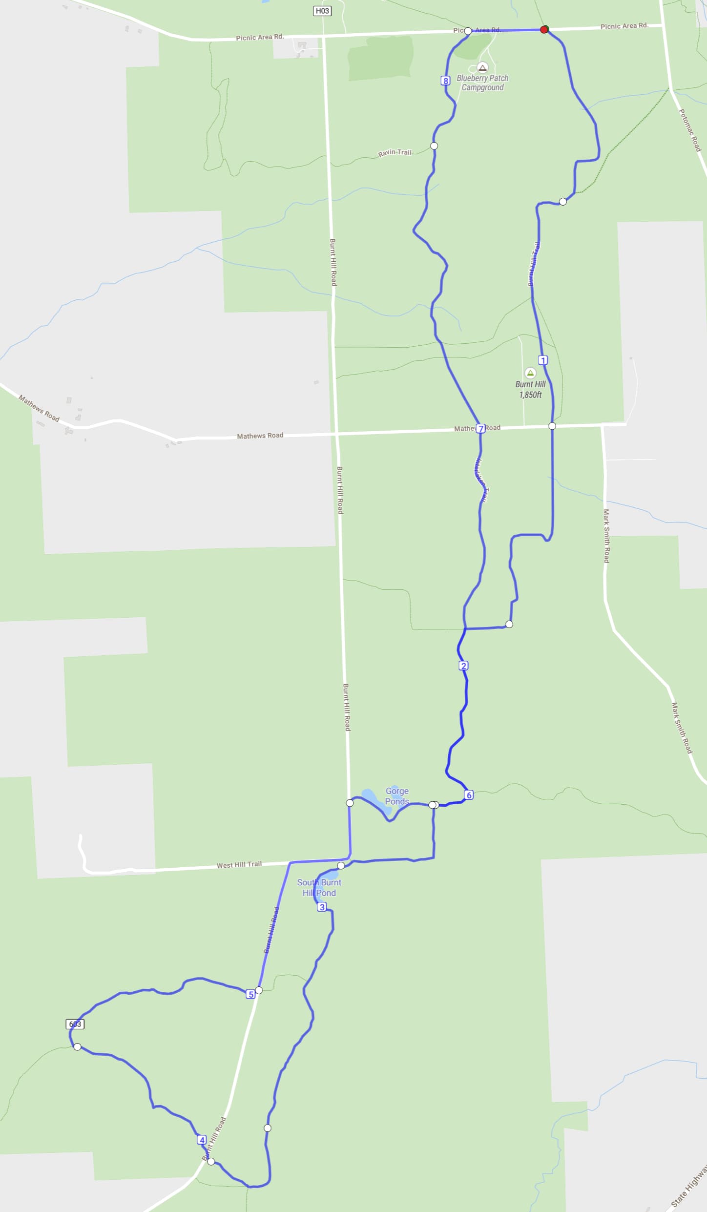
As someone who lived 2.5 miles from the Potomac Campground for many years, I’d say that you’ve mapped out a lovely course in the National Forest. Unless they’ve done improvements in recent years, there are a couple of hundred yards or so directly west of the blueberry patch that can be a bit unpleasant (mud + briars) but it’s brief and maybe is just fine these days.
It’s a nice layout with a good flow to the loop, and many runners may already know their way through it.
The last few times I ran there in April and May the trails were still pretty wet and muddy, especially the Interloken, so the first 1-2 months of the Challenge May be rough going on this course. There’s also tons of ways to get lost, so accurate mapping and RunGo directions are a must. My only other concern is that if you include this and Lime Hollow the courses will be spread out across a wide area.
Love it! You can start/finish right at the campground (you have it to the right at a trail intersection). Per the forest website re: Blueberry Patch Campground: “If you prefer to hike, picnic, or gather berries without camping, please use the first parking lot as you drive into the campground.”
You can also cut out a few complexities near Gorge Ponds with this simplification, too – How far did I run? - Create running maps with On The Go Map
Looks like a fun route! Miss these trails; hoping I can get an Ithaca visit in this summer to run some of the Challenge courses with an altitude adjusted advantage ![]()
Echoing earlier comments - can definitely be wet and muddy in early spring and sometimes sections get overgrown later in the summer, but overall not bad and very runnable. Might be worth noting for runners who have done FL50s in the past that the course is NOT the same - I could see someone who is on autopilot turning east on Mathews Rd to go south on Mark Smith Rd like we do in the FL50s instead of continuing on trail.
Thanks, all! @nkleinrock, @Petorius, @gvanloon, @gplwoo, does @scottpdawson’s approach to the area around the Gorge Ponds look like the best way to do it?
I’m just going by lines on a map here, but my inclination from them would be to cut out Burnt Hill Road entirely and follow the trail that somewhat avoids the Gorge Ponds. But I don’t know if the Gorge Ponds are particularly pretty, or would be a great chance to cool off on a hot day, or what.
And thanks for the fix on the start, Scott—I’ll definitely take that into account.
Going out on the Interloken and back on the Gorge trail follows that portion of the 50s course, so would hold some familiarity for some participants. The extra bit on the road from the last bend in Burnt Hill Road to the campground entrance is very short, so that shouldn’t be much of an issue, but finding the trail by the Gorge Ponds can be a little tricky: You have to enter the campground and then look for the sign for the Gorge Trail (which can be obscured if a car or camper is parked there). I’m not going to get into a discussion about pluses and minuses of becoming reliant on digital crutches for navigating through the natural world, but going out and back on the Interloken in that region would be easier to navigate. HOWEVER, I have another suggestion—provided that the little spur trail at the eastern end of the South Slope Trail is cleared of blowdowns (which was a perennial problem years ago; I have no idea about today’s status). Just take the South Slope straight across Burnt Hill Rd and back to the Interloken, where you’d turn left and continue on orange all the way back to the Blueberry Patch. Here’s a blowup of that section:
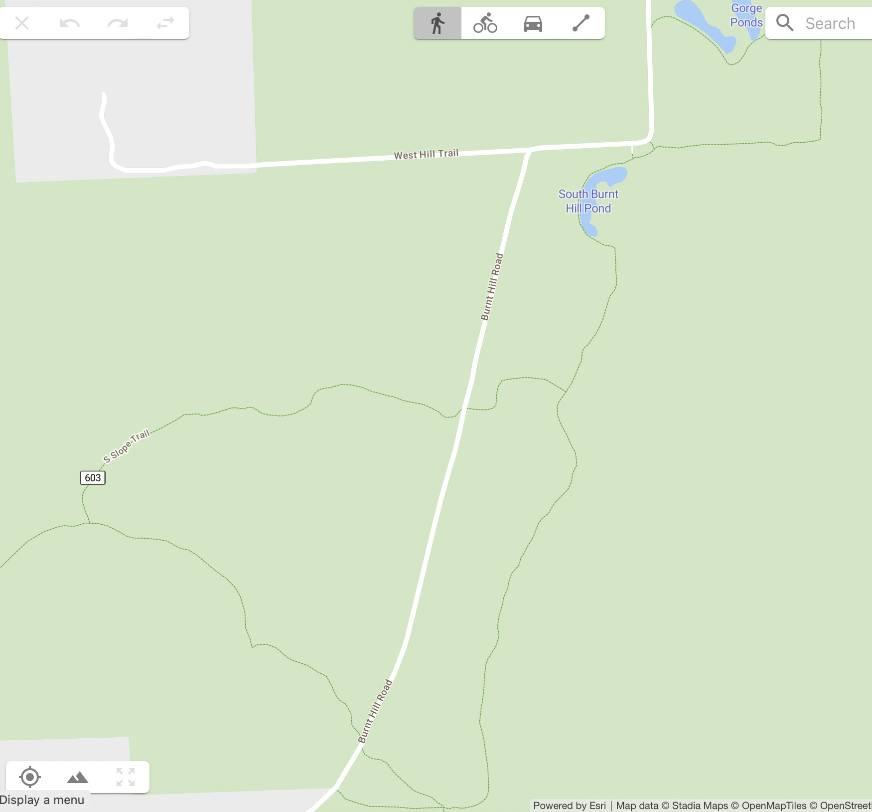
That section isn’t well maintained and is usually overgrown. If we use this route perhaps the Club could commit to maintaining it. I haven’t been on that section of the Burnt Hill Trail between Matthews and the Interloken in a long time; I have no idea how well that part is maintained or marked.
I think @scottpdawson’s route is pretty good. It strays significantly from the FL50s course, but we’re already do so by bypassing Mark Smith Road. The Gorge Trail from Mark Smith to its intersection with the Interloken Trail is the best part of the 50s course, but there’s no logical way to work it into this Challenge course without an out-and-back.
The section of the Burnt Hill Trail between Mathews Road and where it crosses the Interloken is a primarily a horse and snowmobile trail, so it’s wide and not likely to be overgrown. Mud, however, is separate issue. I have no quibbles with Scott Dawson’s map…
So helpful to have people who know these trails… Sounds like I should stick with @scottpdawson’s approach.
We won’t be advertising this as associated with the Finger Lakes 50s course in any significant way—there’s overlap, obviously, but it’s just too different overall. So it’s more about introducing people to the FLNF trails in general.
Blueberry Patch it is!
1 Like
I have nothing to add as I’ve only run in the FLNF once, but thank you for adding this course! I loved running there, super excited for more opportunities for exploration.
That looks like an interesting route as is. If you want to add just a bit of distance, off the NW corner, trail intersection going west before the northern most road, you could add a lollypop that takes in the ravine section.