The FLRC/High Noon cross-country team – and anyone else who is looking for an intriguing 8K run on many surfaces and/or looking to enjoy post-run bagels and cider during (hopefully) glorious fall weather – should mark your calendars for this group run at the lower portion of Robert H. Treman State Park on October 12.
We will be previewing the course for our upcoming race on November 2. (It’s not too late to follow the three steps to sign up - scroll down a little on the linked page to find them.)
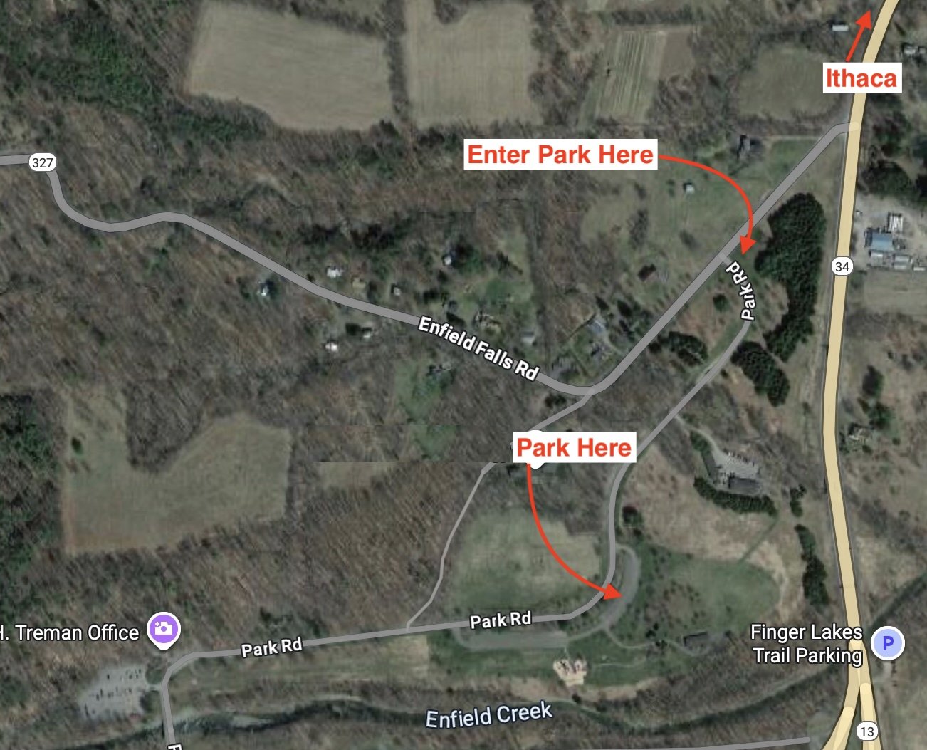
We will meet at 10 AM in the parking lot closest to the north shelter (see map far below) and start running at 10:15. The park may charge a $10 per-car parking fee. If you need a ride or can offer one, say so in the comments to this post.
I recommend light trail shoes or sturdy general running shoes. This is not a spikes course.
** Please RSVP so I can plan food and drink.**
Yes, I’m coming to the run!
0voters
Club membership is not required for this free activity, but please sign the FLRC 2025 Training Programs waiver before your first run this year. You need to sign the waiver only once for all 2025 group runs, so if you’ve already signed it, you’re all set—check here.
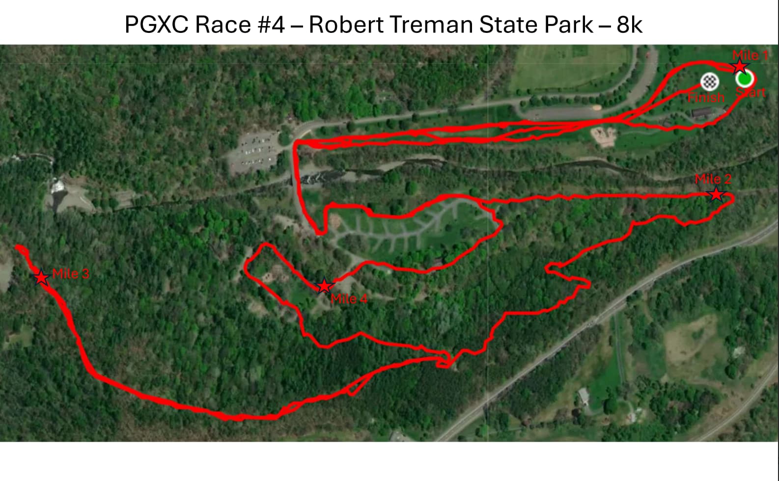
I’ll post the course map here when the time gets closer. Many thanks to @JesseKoennecke for making our course and coordinating race day logistics with the PGXC organizers!
It’s also pretty close to the Lick Brook parking area we used for the Challenge course, so if you wanted to avoid the parking fee, you could park over there and run over to the North Shelter.
Below is the draft map of the course that @JesseKoennecke is working on, plus written directions to help you interpret the map. I ran this a few weeks ago and did fine. I had the map on a printout and the written directions on my phone.I had to stop a few times to orient myself. On race day there will be a lot of flags and course marshals.
If your running pace is different from mine, bring this info on your phone or a printout!
I recommend light trail shoes or regular running sneakers that can handle trails.
First mile: Starts on the field near the big pavilion at Lower Treman, next to the parking lot where we are meeting. Counter-clockwise loop around the fields and along a gravel path out, then go left on the grass shortly before you reach the paved road and run back to the starting area.
Second mile: Loop around the starting area and go back to the gravel path. Run on the gravel path to the paved road. Go left on the road and cross the bridge over the creek. Go left into the campground area and follow the left/outer edge of it, avoiding active campsites. (Actual race will be on grass at far left if there are no campers.) At the end of the campground, run onto a service road for ~.3 miles before turning right onto the Finger Lakes Trail.
Third mile: About .55 miles of single-track trail along the FLT (white blazes). The trail emerges at a service road intersection. Turn right to go UP the service road. Run out and back on this road - turn around just after the 3-mile mark where the road splits.
Fourth mile: Run back down the service road to the intersection, go sharp left to go down the steep gravel road, eventually emerging at the camping area. Cross the road and continue straight to run toward a playground. Turn right twice to run around the playground and complete three sides of flat rectangle.
Last bit: Run around more of the camping area, then turn left to follow the early part of the course back to where it began: after you cross the creek, turn right on the grassy path and then run directly to the end.